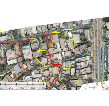
Drainage Solutions
CESTA Enterprise provides an innovative solution for watershed management by utilizing Unmanned Aerial Vehicles (UAVs) to swiftly capture high-resolution images, which are processed into precise Digital Elevation Models (DEMs) ranging from 5cm to 30m resolution. These DEMs facilitate the extraction of morphological features such as basin boundaries, drainage networks, and stream lengths. By adjusting flow accumulation threshold values, our approach ensures the quality of drainage networks, stream characterization, and watershed delineation. This methodology offers a fast, cost-effective, and objective alternative to conventional methods, enabling efficient analysis of watershed areas to mitigate risks of natural disasters like floods, landslides, and erosions. The data generated by our solution is easily interpretable and analysable using GIS, providing valuable insights for urban planning and disaster prevention efforts.
Through our solution, the impact of different flow accumulation threshold values on DEMs at various resolutions is observed, allowing for the optimization of drainage network deformations and shearing effects. The higher spatial resolution of DEMs enhances the discrimination power, enabling better determination of water flow direction and the identification of longer drainage networks. This approach not only aids in assessing and managing watershed areas effectively but also contributes to the establishment of smart cities and the revision of existing urban landscapes to build resilient and liveable environments. We hope to collaborate with your esteemed organization, leveraging our expertise to add significant value to your operations and initiatives in watershed management and disaster prevention.
Utilizing Natural Topographical Slopes for Drain Construction
Integration of Existing Drains with Natural Drainage Systems
Redirecting Drains to Nearest Sinks and Basins
Blocking and Diverting Drains to Prevent Backflow
Adjusting Drain Sizes Based on Water Accumulation
Verifying Drain Depths and Material Utilization
Implementing Effective Drainage System Planning
Reducing Urban Flood Issues through Accurate Aerial Survey
Providing Recommendations for Urban Infrastructure Development
Focus on Sustainable and Efficient Water Resource Management